Showing posts with label Nevada. Show all posts

Saturday, 2 October 2010

More Nevada Desert

Confused, I rose the next morning in Tonopah's surreal clown themed motel. I sat up in my bed and rubbed my head waiting for a sharp hangover to kick in. After a couple of minutes, nothing. I had got away with it. This must have had something to do with with the altitude, or the fact that last nights imaginative barmaid had created cocktails designed to enable you to function the next morning. What a genius. There were too many of her creations for me to remember each of them, however two do immediately spring back to mind; The Pink P**** (Sweet schnapps based. Pink. Tasted like bubblegum) & Dirty Bong Water (I don't know what was in this, but it was green and forced an uncontrollable facial gurn after every sip).

The Clown Motel. Tonopah

Long Straight Road

By 11am we had got back on the road to continue our journey east on Highway 6. Like the day before, the scenery remained vast and empty, and the roads remained long and straight. To our right we passed the huge and depressing Nevada Nuclear Test Site, where between 1951 and 1992, there were an unbelievable 928 "announced" controlled nuclear explosions. There is something deeply sobering about the consequences of that and all nuclear testing during this period. The proliferation that was its consequence has made the world a far more dangerous place, and jeopardised the very existence of every man, woman and child on the planet. Why any nation state anywhere feels it has the right to develop weaponry that can destroy the whole planet is beyond me. It truly is human and political arrogance of the worst and most dangerous kind.

Here are some of the local consequences of this testing...

A 1979 study reported in the New England Journal of Medicine concluded that: A significant excess of leukemia deaths occurred in children up to 14 years of age living in Utah between 1959 and 1967. This excess was concentrated in the cohort of children born between 1951 and 1958, and was most pronounced in those residing in counties receiving high fallout.

National Cancer Institute (1997) - determined that 90 atmospheric tests at the Nevada Test Site (NTS) deposited high levels of radioactive iodine-131 ... doses large enough, they determined, to produce 10,000 to 75,000 cases of thyroid cancer.


A Dead Cow

About a third of the way between Tonopah and the Utah state border we swung a right, down State Route 375, which is otherwise known as the "Extraterrestrial Highway". This lightly traveled road was rerouted past the infamous (CIA named) Area 51 following the nuclear testing in the 1950's, and is now a magnet for conspiracy theorists and sky gazers to come and stare excitedly at the stars.

We didn't see anything.

The "Town" of Rachel on the Extraterrestrial Highway

Eventually, the desert was replaced by vegetation, and the welcome sight of greenery and humanity.

After a delicious breakfast in Caliente and with a sigh of relief, we rolled the Beast into Utah and the prospect of three potential highlights of the trip; the state parks of Zion, Bryce & Moab.

Utah State Border

© All Images By Paul

Wednesday, 29 September 2010

Nevada Desert

Despite the fall of darkness, and with fear of further vehicle failure coursing through our veins, we escaped from Reno. Our first aim was to return to California and to head towards Tahoe's southern shore via the postcard towns of Auburn and Grass Valley. These manicured and pretty detours each offered character and history, but each also failed to offer an incentive to remain longer then a couple of hours. Therefore, after one final night in California we stocked up with water and fuel and headed back towards the vast nothingness that dominates so much of the state of Nevada.

Following a short ride on Highway 50, the transition to desert was rapid and severe. Within an hour we were within the rural flatlands of Douglas County. An hour further as we headed southeast on Highway 95, the only vegetation that could be seen was a sparse covering of dry coarse shrubs over an endless layer of light brown dust. As we continued the air became drier and drier and the need for regular hydration quickly intensified. We were in a vast bowl of emptiness that stretched all around us. Only the occasional derelict structure and forgotten town blemished this intimidating lunar landscape. Each of these stood, slowly decaying like failed acts of defiance that forgot just how inhospitable so much of this state is.

Walker Lake

Ghost Town

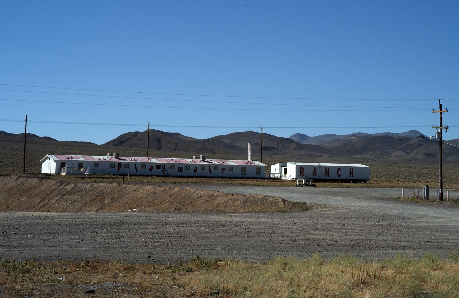
After we had crossed 3 almost infinite straight roads into the horizon, Nevada's more sinister side was exposed. Hawthorn Ammunition Depot, a huge facility that is used to stockpile weaponry emphasised the shear scale of American military strength. Further still, isolated brothels (it's legal in this state) also stood, remote and hidden like the dirty desperate secrets that they facilitate.

"Playmate Ranch" A Legal Nevada Brothel

That night we rolled into a small mining town established, and seemingly forgotten by the tough Wild West pioneers who have been so heavily and justifiably romanticised in American history. Tonopah, which sits in the middle of Highway 95 is best known for its association with the perhaps the most famous American peace officer who ever lived; its former sheriff Wyatt Earp. This is a place where people come to be forgotten, and the towns’ bar is where those forgotten people congregate to ply travelers like us with warmth, friendliness and round after round of free drink. Honestly, I don’t think that I have ever experienced such immediate friendliness anywhere else in the world.

Tonopah

Tonopah Founders Graveyard

© All Images By Paul

Friday, 24 September 2010

Reno

Following a late evening check-in at Reno's Peppermill Resort and Casino I was overwhelmed and disorientated by a neon blur and the ringing of slot machines. Seemingly endless strips of bright lighting clung to every wall and made finding our room intensely difficult. However, a 70's styled black and mirrored room which included a personal bar and jacuzzi, justified the search and set up a perfectly relaxing evening and a good nights sleep.

Inside The Peppermill Resort and Casino

The next day started well enough. We had agreed to do the photography for a wedding up in the beautiful hills that shroud this sprawling and tired older cousin of Las Vegas, and so set off to start work with the wedding location programmed into our Garmin (Sat Nav). This is when things started to go wrong. The maps loaded into this device were obviously out of date and so sent us up a dirt track dotted with potholes and trenches that each took their toll on the Beast. After arrival, the extent of this toll was realised as it slowly sunk before our eyes. Our rear left wheel had dislocate itself from the body of the vehicle. Bugger.

After a call to AAA, a tow courtesy of an entertaining fantasist with no teeth, and much chin scratching by a local mechanic, it soon became clear that we were trapped and would have to wait a further 2 days to make the Beast roadworthy. We were not going to be leaving Reno anytime soon.

Old Town Reno

My first thought after a quick tour of old Reno was that this prospect did not seem unpleasant. However, after 2 days trapped inside the Peppermill, my perception certainly changed. The disorientation felt upon arrival was quickly replaced my nausea. Upon closer inspection, the staples and gaffer tape that hold the rickety and ostentatious aesthetic of this place soon became very clear. In addition, the wall-to-wall mindless gambling opportunities and the people spending so much of their hard earned money made me sad and resentful of such flagrant wastefulness.

After 2 days trapped in a city that you can not navigate as a pedestrian, the eventual resurrection of the Beast was greatly appreciated. It was certainly time to get out of here.

© All Images By Paul
.

Thursday, 23 September 2010

Lake Tahoe

This was our first real opportunity to head inland and away from the long Pacific coastline. So with the Beast temporarily converted back to its primary function of vehicle rather then mobile home, we headed east along Highway 80 towards the alpine beauty of Lake Tahoe. Located in the Sierra Nevada mountains, Tahoe is undeniably picturesque. I had visited this area once before within the dead of winter, when the mountain sides shone a brilliant white under many feet of snow (picture from previoius trip). However this time, under a strong Indian summer, a rich pallet of colours had emerged to greet us. As I looked out over the mirror like lake I couldn't help but think that my eyes were deceiving me as the rich green of a thick woodland was sandwiched between the deep blues of the sky and water. The view looked like a doctored photograph; a complete contrast to the muted tones and diffused light of home, which over many years have dulled my expectation of nature.

Lake Tahoe

That evening we headed over the peaks that dominate the circumference of Lake Tahoe on the way to Reno and the Nevada state border. This involved pushing the Beast to its limits with rises and dips that dwarfed anything I had driven on previously. We had been advised to follow the small mountain pass that is Route 28, and as soon as we crossed the final peak of that mountain range I realised why. There are few words in my limited vocabulary that are capable of describing the view down into Nevada with any justice. All I can say is this is by far the longest and most impressive uninterrupted vista I have ever seen.


Following that treacherous road east and down towards Reno immediately sobered any emotional reaction I was having towards the local environment. This road was going to take its toll unless I dedicated every ounce of concentration in my small brain.
However concentrate I did and eventually, under a rapidly descending blanket of darkness, we entered Reno.

The Sky Over The Nevada Border

© All Images By Paul
.